Our Lunar Legacy
Experience
Online Exhibit
Overview
Created as part of Flagstaff’s Lunar Legacy celebration, our online exhibit explores Lowell Observatory’s role in preparing for the Apollo Moon missions, with special focus on lunar mapping and astronaut training.
One Giant Leap
Lowell Observatory's Key Role
Lowell Observatory played a key role in preparing for the Apollo Moon missions a half century ago, as artists teamed with scientists to create detailed lunar maps. Several of the Moon-bound astronauts even visited Lowell in 1963 to study these maps.
Mapping the Moon
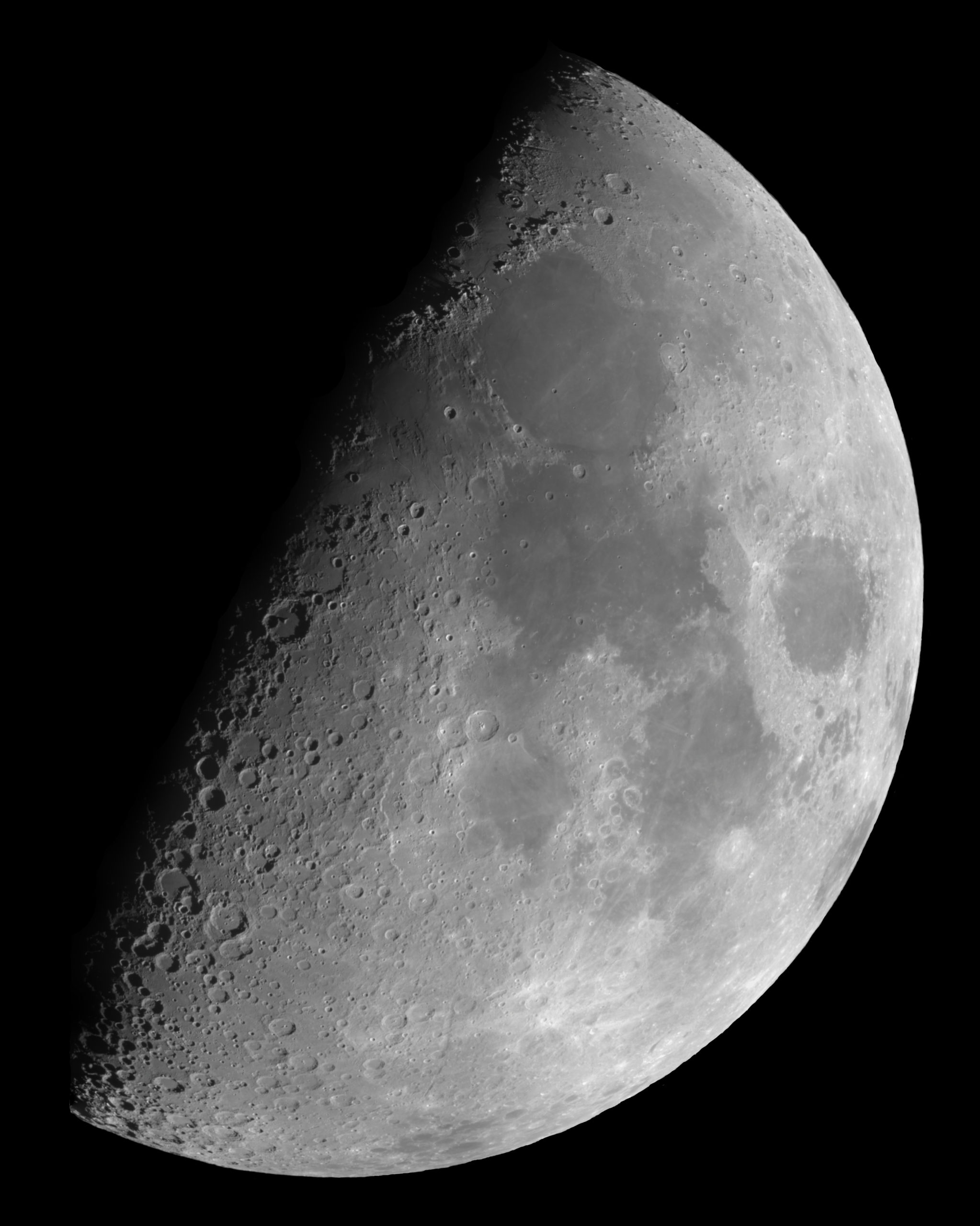
In a defining moment of the 20th century, astronauts Neil Armstrong and Buzz Aldrin broke the bonds of Earth and stepped onto the Moon on July 20, 1969.
This singular achievement was accomplished due to the efforts of hundreds of thousands of people and organizations, including cartographers at Lowell Observatory.
The story kicks off in the fall of 1960, when a man from St. Louis named William Cannell visited the United States Naval Observatory’s Flagstaff Station to gaze at the Moon through one of the facility’s telescopes. Cannell was a cartographer working for the Aeronautical Chart and Information Center (ACIC), a branch of the U.S. Air Force then creating lunar charts.
Cannell was on a mission to find a telescope for carrying out a sustained Moon mapping effort.
He learned from observatory director Art Hoag that all the telescopes under his control were already in regular use. Hoag did prove quite helpful, however, advising Cannell to talk with John Hall, director of nearby Lowell Observatory, to see if Lowell might have a telescope available for such a project.
Cannell approached Hall, who was very happy to offer the 24-inch Clark refracting telescope, ideal for the observations and also available for use. Throughout the following year, Cannell and occasionally an assistant or two would visit Lowell a few days a month to make observations. In the late summer of 1961, the Moon mapping effort at Lowell escalated when the ACIC opened an office on site, ushering in a time during which telescope observers, photographers, and scientific illustrators focused their energies on creating dozens of maps of the Moon using the Clark Refractor.
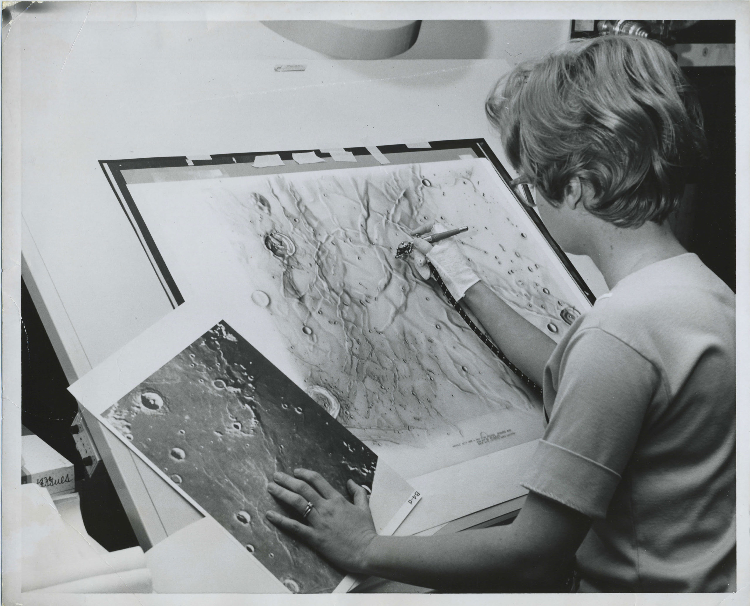
For the first several years, the talented young artist, Patricia Bridges, served as the primary illustrator.
Cannell managed the office and for the first several years a talented young artist, Patricia Bridges, served as the primary illustrator, using an airbrush to record artistic yet accurate renderings of mountains, craters, valleys, and other features of the Moon. The airbrush technique resulted in maps rich in detail and character. Telescope observers made primary observations through the Clark and then Bridges used these basic drawings, supplemented by lunar photographs and her own observations through the Clark, to craft her maps.
The ACIC effort expanded during its time at Lowell, adding another telescope, enlarged office space, and a motion picture camera for supplementing the visual observations through the telescope. Bridges eventually left the ACIC office to raise her kids, opening the door for another talented illustrator, Jay Inge, to take her place. Inge continued on through the end of the program in 1969 and played a key role in developing the last product of Lowell’s ACIC office, a spectacular 16-inch-diameter lunar globe that surpassed all previous ones in details and accuracy.
All told, the ACIC staff created the globe and nearly 90 lunar charts, most based on telescope observations but some from data collected by Ranger, Lunar Orbiter and Surveyor spacecraft. These maps were critical to understanding the nature of the lunar surface and some were used by the Apollo astronaut program for determining landing sites.
Adapted from The Far End of the Journey: Lowell Observatory’s 24-inch Clark Telescope, Kevin Schindler, 2015.
Astronauts Land at Lowell
While the cartographers prepared Moon maps at Lowell, the astronauts themselves came to Flagstaff as part of their training. They studied the geology of Meteor Crater, the Grand Canyon, and various cinder fields while practicing many aspects of their missions. The first group of astronauts to train in northern Arizona—the so-called Next Nine, which included the likes of Neil Armstrong, Jim Lovell, Frank Borman, and others—also went to Lowell Observatory on a winter day in 1963 to learn mapping techniques from the Moon mapping team.
Wednesday, January 16, 1963 dawned cold in Flagstaff as about 40 Flagstaff dignitaries and scientists met the astronauts at the Flagstaff airport just after 7:30 a.m., the mercury reading -5˚F. Mayor Rollin Wheeler formally declared that January 16 was “Space Age Day” in Flagstaff and welcomed the astronauts and the half dozen NASA officials that accompanied them.
The group first went to Meteor Crater, where U.S. Geological Survey astrogeologists Gene Shoemaker and Charles Marshall taught the astronauts about this distinct impact structure that serves as an excellent analog to similar features on the Moon. The group later traveled to Sunset Crater to study volcanic features.
After this daytime training, Lowell director John Hall hosted dinner for about 35 people at his recently built Lowell Observatory home. The astronauts, trainers, and other dignitaries enjoyed a buffet dinner prepared by Hall’s wife Ruth. Years later Lowell astronomer Henry Giclas recalled the event. “Even though before-dinner libations were served, things started out rather stiffly with all the NASA brass on their good behavior. Then Bernice (Henry’s wife) made some smart remark about the only experience she knew about exploring the Moon was when the cow jumped over it, which cracked everybody up, and the party took on a much more relaxed and informal mood.”
With dinner over, the group headed over to the Moon mapping offices, where officials briefed the astronauts on lunar geography and geology while teaching them about the ACIC’s mapping efforts.
At midnight the contingent broke up into three groups for telescope viewing. See, White, and McDivitt stayed at Lowell to use the Clark 24-inch Telescope. Borman, Stafford, and Armstrong, who ended up being the commanders of the first three manned missions to the Moon, went to Arizona State College (today known as Northern Arizona University) to use their 24-inch reflector, while Navy men Lovell, Conrad, and Young headed to the U.S. Naval Observatory and its 40-inch reflector.
The observers saw Mars and the Moon among other celestial objects. While viewing the Moon, they correlated lunar features to the terrestrial ones they had seen in the field at Meteor Crater and Sunset Crater.
Some of the astronauts finished telescope viewing by 2:30 a.m., the others not until 3:30. Their jam-packed schedules allowed them only four hours of sleep that night, prompting future moonwalker Pete Conrad to comment, “One thing you can say for the space program, it has invented the 26-hour day.”
The Moon mapping and related astronaut training was the last sustained research program carried out with the Clark, though some smaller-scale projects continued for several years. Today, evidence of the Moon work done at Lowell during those heady days of Apollo is sparse. The illustrators, observers, and photographers have long since retired and the detailed charts they created are neatly stored for posterity. The section of the ACIC office not torn down years ago has been completely renovated and now houses the observatory’s business staff, all signs of its former use gone. The one exception is the Clark; today, Lowell staff continues to point it at the Moon (during its first quarter phase) each month, affording visitors an opportunity to follow in the footsteps of the astronauts and Moon mappers alike while exploring this marvelous world.
Adapted from The Far End of the Journey: Lowell Observatory’s 24-inch Clark Telescope, Kevin Schindler, 2015.
Highlights of Lowell’s Lunar Legacy
Other Places to Visit
Lowell wasn’t the only place in northern Arizona to help pave the way to the moon. Explore these notable attractions found only in Flagstaff!
The geology of northern Arizona is dominated by the San Francisco volcanic field, which contains hundreds of volcanoes and is overlaid by a variety of lava flows and other deposits of rock similar to what geologists expected to find on the Moon. These features made it an ideal place to develop and test instruments that would be used on the Moon, as well as to train the astronauts for their lunar excursions.
The area in and around Sunset Crater Volcano Monument was especially well suited and geologists, engineers, and astronauts frequented here from 1963 through the end of the Apollo era, in 1972.
One common testing/training locale was Bonito Lava flow, which originated on the eastern base of Sunset Crater. This site was used for testing cameras and hand tools, practicing geological sampling techniques, and simulating the on-Moon activities of the astronauts.
Manmade Crater Fields Near Sunset Crater
One of the most critical issues the astronauts would encounter after reaching the Moon was to pinpoint their location. They would have to be able to survey the landscape and identify craters and other topographic features as depicted on Lunar Orbiter photographs and maps created by Flagstaff scientists. If they were unable to do this, they would be lost on the Moon. The astronauts had to become experts at identifying topographic features, and this meant hours of training beforehand. U.S. Geological Survey personnel found, or rather created, an ideal setting to carry this out, across a cindered terrain near Sunset Crater.
In 1967, technicians plotted a network of craters in this field. Using images of a lunar landscape near the Moon’s Mare Tranquillitatis as a guide, they dug holes with a backhoe, filled them with explosives, covered the holes, and set off a sequenced blast. The result was a simulated lunar surface with 47 craters ranging in diameter from five to 40 feet. The field was valuable not only for crater identification exercises but also for practice collecting geological samples, testing hand tools, and driving prototype rovers. Cinder Lake Crater Field #1, as it became known, proved quite useful and in October, another 96 craters were added. The field covered 640,000 square feet but was still not big enough for the heavy use it was seeing, so technicians created a second site, Cinder Lake Crater Field #2, in July 2018 and adjacent to the original field.
The Cinder Lake Crater Field complex had one significant drawback: wintertime use. The temperatures could be quite cold and snow often covered the area. Officials thus decided to create another, more southerly, field, in February 1970. Located 60 miles southwest of Flagstaff in the Verde Valley, this 35-acre field featured some 380 craters measuring from six to 82 feet in diameter.
These crater fields were used until the end of the Apollo program. Fifty years later, they show the wear caused by the ravages of nature and man. A few crater remnants in Verde Valley can still be seen, though most have naturally filled in with mud. At the Cinder Lake Crater Field complex, many of the craters are in the middle of a recreational area and regularly pounded by dune buggies and other recreational vehicles. Luckily, another area was fenced off years ago and contains dozens of well-preserved craters, many with their raised rims still distinct.
All of the crater fields are located on public land and open to anyone to explore. And guests to Sunset Crater Volcano National Monument can visit the rugged Bonito Flow and other spots where the astronauts trained.
Adapted from Arizona Daily Sun article, “Manmade craters of Flagstaff trained astronauts”, Kevin Schindler, July 15, 2017
More than two million people have visited the Grand Canyon since it was designated a national park nearly a century ago. While there, these pilgrims typically have found inspiration in the resplendent layers of rock. In the mid-1960s, local geologists realized that they could draw on such revelations to stimulate a group of jet pilots to want to learn about geological principles, information they could use on future flights. But these flights wouldn’t visit foreign cities or countries, but a foreign world.
The pilots were Apollo astronauts, and, under the guidance of the geologists who were working on behalf of NASA, they hiked into the Grand Canyon in preparation for their missions to the Moon. In fact, all 12 of the astronauts who flew around the Moon, and 11 of the 12 who set foot on the lunar surface, participated in these training exercises. The one Moonwalker not accounted for? That would be Harrison “Jack” Schmitt, who was a geologist by trade and so didn’t need further training in the Grand Canyon. Schmitt was the only scientist to walk on the Moon and, in fact, was working at the United States Geological Survey in Flagstaff when he was chosen to be one of NASA’s scientist-astronauts.
This astronaut training transpired over three trips. The first was on March 5-6, 1964 and consisted of 18 astronauts, including future moonwalkers Neil Armstrong, Buzz Aldrin, Alan Bean, Alan Shepard, Dave Scott, and Gene Cernan. A week later, future moonwalkers Pete Conrad and John Young were part of a group of 11 to visit. Finally, on June 2-3, 1966, a group of 19 that included future moonwalkers Edgar Mitchell, Charlie Duke, and Jim Irwin made the trek into the Canyon.
All three hikes followed the same plan. The astronauts flew into Flagstaff and then drove with geologists to the Canyon. After a briefing at the Yavapai Geology Museum, the group headed to the trailhead of South Kaibab Trail and made broad-scale observations of the Canyon. They then broke up into small groups, with two or three astronauts and a geologist in each group, and began hiking down, studying the general superposition of rock layers, as well as more detailed features such as the fossils of the Kaibab Limestone and cross bedding in the Coconino Sandstone. While the geologists knew these particular types of rocks, not to mention the fossils, would not be on the Moon, they nevertheless found their characteristics useful in teaching large scale geological processes. Plus, they had the undivided attention of the astronauts; teaching geology to a group of pilots with limited interest in geology was much easier to do in the grandeur of the Grand Canyon than in a classroom.
The hikes turned into crash courses in geology, with the astronauts each carrying and using geology hammers, hand lenses, compasses, field notebooks, and other tools of the trade. The groups slowly descended the South Kaibab, periodically stopping to examine rock crystals or study rock charts. They finally made it to the bottom and Phantom Ranch, where they had to survive the annoyance of skunks and rustic sleeping conditions. The next morning they hiked up Bright Angel Trail, with the astronauts recalling what they had learned the previous day. Many rode mules out from Indian Gardens, though some of the more driven astronauts, including the hypercompetitive Alan Shepard, insisted on hiking out.
The Grand Canyon experience proved beneficial for the astronauts, helping them gain an appreciation for the vastness of geologic time and the magnificent forces involved with forming and, eons later, exposing rocks.
Today, hikers can walk in the footsteps of the astronauts and explore the layers of rocks just like they did.
Adapted from Arizona Daily Sun article, “Manmade craters of Flagstaff trained astronauts”, Kevin Schindler, July 15, 2017
Through the middle of the 20th century, the origin of Meteor Crater, located some 35 miles east of Flagstaff, was uncertain. Some scientists believed it was the result of a volcanic steam explosion while others thought it was caused by the impact of a large meteorite.
Starting with a series of papers in 1959, US Geological Survey geologist Gene Shoemaker showed conclusively that only an extraterrestrial projectile could produce the enormous pressures evidenced in the crater.
When the astronauts began training for their lunar missions, Meteor Crater was, as an apparent analogy to craters on the Moon, naturally included on their itinerary. In January 1963, on the same trip that included stops at Sunset Crater, Lowell Observatory, and Northern Arizona University, Shoemaker led a two-day training of nine astronaut recruits. This kicked off the geological training of the astronauts and everyone who would eventually travel to the Moon first trained at Meteor Crater, Sunset Crater, the Grand Canyon, and other areas in northern Arizona.
Today, visitors to Meteor Crater can see where the astronauts studied geology and understand why this was such an important place to train for the Moon.
The US Geological Survey was the hub of Apollo-related activity in northern Arizona. Cartographers created the first geological maps of the Moon and scientists and engineers developed geological procedures, built and tested equipment including the lunar rover trainer known as Grover (the Geological Rover), trained astronauts, designed and created the man-made crater fields, assisted with simulated Moon walks, and even served in the Mission Control support rooms at the Johnson Space Center during the missions.
While the USGS doesn’t currently offer regular public tours of its facilities today, guests may still drop in at the Shoemaker Building and see artifacts such as Grover, astronaut handprints in cement, maps, and more.